Ancient Footprints Revealed at Lunan Bay After Winter Storms!
Winter storms along Scotland’s east coast recently uncovered an extraordinary glimpse into the past at Lunan Bay, near Montrose. Powerful winds and waves stripped away layers of sand from the dunes, revealing a patch of ancient clay hidden beneath. What appeared next was remarkable: a series of clearly defined footprints left in the mud roughly 2,000 years ago.
The discovery happened in late January when two local residents, Jenny Snedden and Ivor Campbell, were out walking their dogs along the beach. As they crossed the exposed clay surface, they noticed something unusual: impressions of feet pressed into the hardened mud. Some appeared to be human, while others looked like animal tracks, all preserved in striking detail.
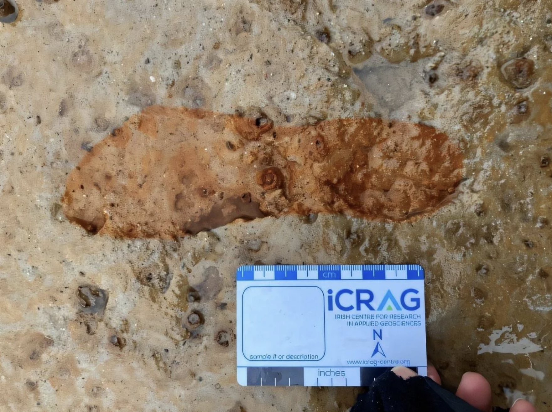
Photo Credit: University of Aberdeen
Realising the potential significance of what they had found, Campbell contacted regional archaeologist Bruce Mann on 26 January. The following day, a team from the University of Aberdeen arrived at the site. They knew they had very little time to work. The same storm conditions that had revealed the footprints were already threatening to destroy them.
With winds reaching more than 55 miles per hour, sand was blowing across the clay surface while the tide steadily eroded the edges of the exposed area. The researchers quickly gathered equipment on their way to the beach, including plaster for making casts of the footprints before they disappeared.
Professor Kate Britton and her team immediately began documenting the site. They carefully cleared parts of the clay surface, mapped each visible footprint, and created detailed 3D models using photography and drone footage. Whenever the weather briefly calmed, drones were flown overhead to capture highly accurate aerial images of the impressions.
At the same time, the team made physical plaster casts of some of the best-preserved footprints before the next high tide arrived. Their urgency proved justified, within just 48 hours the clay layer that held the prints had completely disappeared beneath sand and seawater.
Back in the laboratory, the researchers examined plant remains preserved in the sediments beneath the footprints. Radiocarbon dating showed that the tracks were made around 2,000 years ago, during the late Iron Age. This period coincided with Roman expansion in Britain and occurred centuries before the Picts became established in eastern Scotland.
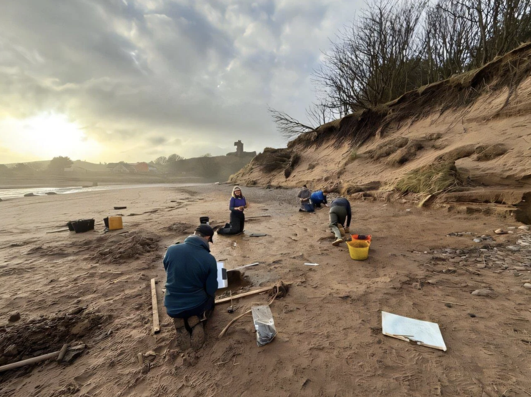
Photo Credit: University of Aberdeen
Closer analysis revealed a mixture of human and animal prints. Among the animals identified were red deer and roe deer, along with other species. The human footprints appear to have been made by barefoot individuals, and the spacing and size of the prints suggest that both adults and possibly younger people crossed the area.
At the time the tracks were made, the landscape looked very different from the wide sandy beach visitors see today. The clay surface likely formed within a muddy estuary or salt marsh environment. Two thousand years ago, this area probably supported marsh vegetation and attracted grazing deer. People may have visited the area to hunt, fish, or gather coastal plants such as samphire.
Footprint sites like this are rare. Similar discoveries have previously been made in places such as the Severn Estuary, Formby in Merseyside, and Happisburgh in Norfolk. However, this is the first documented example of such a site in Scotland. As a result, the discovery provides rare and direct evidence of human activity along the Angus coastline during the late Iron Age, while also highlighting how dramatically coastal landscapes can change over time.
Bruce Mann also emphasised the importance of the quick thinking shown by the two walkers who reported the find. Without their prompt action, the footprints would likely have vanished without ever being recorded. In fact, the same storm that revealed the ancient clay layer destroyed it again within a matter of days.
Although the physical site has now disappeared, the data collected by the research team remains extremely valuable. The drone images and 3D models will not only preserve a record of the footprints but will also help scientists monitor coastal erosion in the Montrose basin.
With rising sea levels and increasingly powerful winter storms reshaping the shoreline, buried clay layers like the one at Lunan Bay may be exposed again in the future. If they are, they could reveal more traces of the people and animals who once moved across this coastline two millennia ago.