Hidden Chambers Discovered Near Italy’s Prehistoric Cave of Venuses!
Researchers investigating a prehistoric cave in southern Italy have identified evidence of possible underground cavities that could reveal previously unexplored sections of the site. Their findings also highlight fractures in the surrounding rock, raising important questions about the stability of the cave ahead of planned restoration work.
Known as Grotta delle Veneri, or the Cave of Venuses, the site is an important archaeological location containing evidence of prehistoric human activity, including remains associated with Neanderthals and early modern humans.
The cave lies near Parabita in the Apulia region, approximately 25 miles south of Lecce. It gained archaeological attention following excavations in 1966, when researchers uncovered human remains attributed to different periods of human evolution, alongside two small figurines depicting pregnant women.
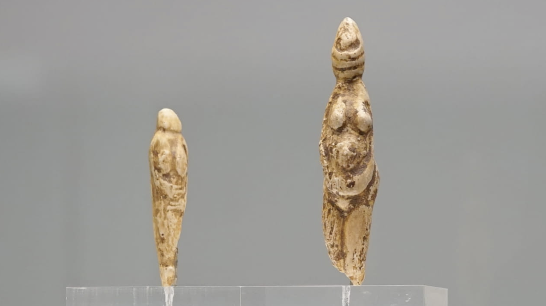
Photo Credit: Fabrizio Garrisi/Wikimedia Commons, Public Domain
These figurines are among the site's most distinctive discoveries, while other finds demonstrate that the cave was used over an extended period. Material recovered from Upper Palaeolithic deposits includes stone tools and decorated bone objects, with further evidence indicating human activity during the Neolithic and Metal Ages.
The latest research was undertaken to investigate the underground geology surrounding Grotta delle Veneri and establish whether previously unknown cavities might exist beneath the surface. The work also forms part of preparations for restoration intended to improve visitor access while protecting the archaeological site.
Rather than excavating the ground, the researchers used two geophysical techniques to examine what lies beneath the surface: ground-penetrating radar (GPR) and electrical resistivity tomography (ERT).
Ground-penetrating radar works by transmitting electromagnetic waves into the ground and recording the signals reflected by buried structures and changes in the surrounding material. These variations can help identify potential voids, fractures and other features hidden beneath the surface.
Electrical resistivity tomography takes a different approach, measuring how readily an electrical current travels through underground materials. Differences in resistance can reveal variations in the composition of the ground, helping researchers identify possible empty spaces, fractured rock and areas containing loose deposits.
Combining the two techniques allowed the team to compare their results and develop a more detailed picture of the underground landscape.
The investigation covered three separate areas, labelled A, B and C. Although dense vegetation, uneven terrain and exposed rock restricted access in places, radar surveys were completed across all three zones. Two-dimensional and three-dimensional electrical resistivity surveys were also carried out where conditions permitted.
Area A produced some of the most promising results. Radar data revealed substantial underground anomalies measuring approximately eight to ten metres across, with their upper boundaries located between 0.9 and 2.7 metres below the surface.
The characteristics of these signals suggest that the features could represent cavities connected to, or associated with, the known cave system. However, further investigation will be required to determine whether they contain open spaces and whether any passages link them to the existing chambers.
The same area also produced evidence of possible fractures in the underlying rock. These features are particularly significant because weaknesses in the surrounding limestone could affect the stability of the cave and need to be considered when planning conservation work.
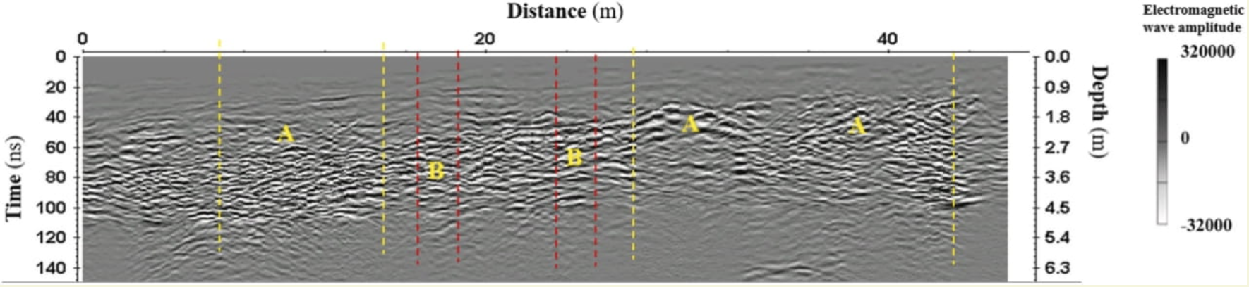
Photo Credit: D. F. Barbolla et al., Digital Applications in Archaeology and Cultural Heritage (2026)
Potential cavities were also identified in the other two survey areas.
In Area B, the suspected underground features were smaller, measuring approximately 0.5 to one metre across. Their upper surfaces were detected at depths of around 1.8 to 3.6 metres.
Area C revealed larger anomalies, with estimated widths of four to five metres. These features were located at varying depths, with their upper boundaries between 0.9 and 3.6 metres below ground level.
Although the dimensions and depths differed between the three areas, the results indicate that several parts of the surrounding ground could contain previously undocumented underground features.
The electrical resistivity measurements provided additional support for a number of the radar anomalies. Some underground areas displayed particularly high electrical resistance, which can be consistent with empty cavities within limestone.
Other zones produced lower resistance readings, potentially indicating fractured rock or loose material that has accumulated within underground spaces.
Comparing these measurements with the radar data helped researchers assess the likely nature of the anomalies. Neither technique can establish the presence of a cavity with complete certainty on its own, particularly in complex limestone environments where moisture, cracks and sediment-filled voids can produce similar readings.
Nevertheless, using both methods together offered a more reliable basis for interpreting the underground features without disturbing the archaeological remains.
The possible fractures identified near the cave are another important aspect of the research. Radar signals suggested that some cracks could be open, highlighting areas that may warrant closer examination as conservation plans progress.
Understanding the location of these weaknesses could help specialists assess potential risks and determine which parts of the site require further monitoring before restoration work begins.
The findings provide a new picture of the ground surrounding Grotta delle Veneri and raise the possibility that additional underground spaces remain undiscovered. If future investigations confirm that some of these cavities connect to the existing cave, they could expand researchers' understanding of the site's physical structure.
For now, however, the suspected chambers remain unconfirmed. Geophysical surveys can identify features consistent with underground voids, but archaeological investigation will be needed to establish their precise nature, extent and relationship to the known cave.
The results are also valuable for conservation. Identifying fractures and potentially unstable areas before restoration begins could help specialists make informed decisions about how to protect the site while improving public access.
With evidence of prehistoric activity spanning multiple periods, Grotta delle Veneri remains an important location for understanding human presence in southern Italy. The latest research offers a way to investigate what may lie beneath its surroundings while leaving the ground undisturbed, providing a foundation for future archaeological study and preservation.